File:Termessos Upper city wall 7212.jpg
Page contents not supported in other languages.
Tools
Actions
General
In other projects
Appearance
Size of this preview: 800 × 532 pixels. Other resolutions: 320 × 213 pixels | 640 × 426 pixels | 1,024 × 682 pixels | 1,280 × 852 pixels | 2,560 × 1,704 pixels | 4,928 × 3,280 pixels.
Original file (4,928 × 3,280 pixels, file size: 12.7 MB, MIME type: image/jpeg)
This is a file from the Wikimedia Commons. Information from its description page there is shown below. Commons is a freely licensed media file repository. You can help. |
Summary
DescriptionTermessos Upper city wall 7212.jpg |
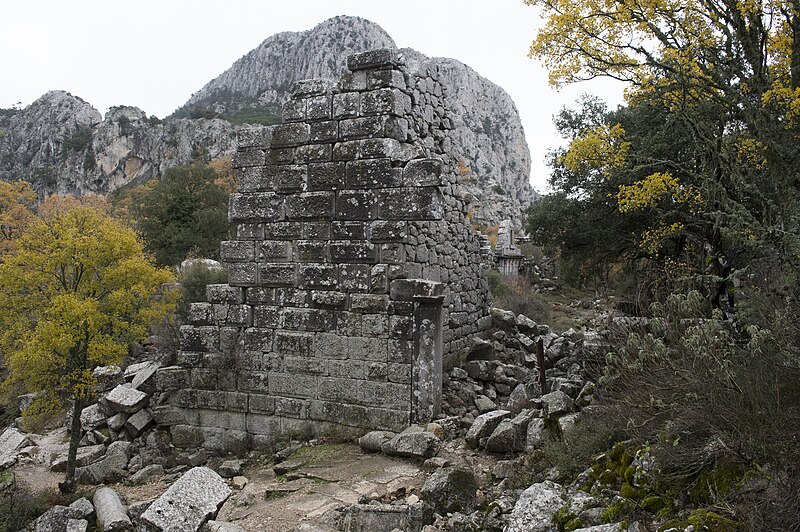
English: Along the higher parts of the King's Road one will see to the left high defensive walls. This is the point where they reach the area of the colonnaded street (in our back) and the road to the gymnasium (part of which is visible). |
Date | |
Source | Own work |
Author | Dosseman |
Camera location | 36° 59′ 03.71″ N, 30° 27′ 48.5″ E | View this and other nearby images on: OpenStreetMap | 36.984365; 30.463473 |
---|
Licensing
I, the copyright holder of this work, hereby publish it under the following license:
This file is licensed under the Creative Commons Attribution-Share Alike 4.0 International license.
- You are free:
- to share – to copy, distribute and transmit the work
- to remix – to adapt the work
- Under the following conditions:
- attribution – You must give appropriate credit, provide a link to the license, and indicate if changes were made. You may do so in any reasonable manner, but not in any way that suggests the licensor endorses you or your use.
- share alike – If you remix, transform, or build upon the material, you must distribute your contributions under the same or compatible license as the original.
Items portrayed in this file
depicts
36°59'3.714"N, 30°27'48.503"E
19 December 2012
0.00625 second
28 millimetre
1,250
image/jpeg
File history
Click on a date/time to view the file as it appeared at that time.
Date/Time | Thumbnail | Dimensions | User | Comment | |
---|---|---|---|---|---|
current | 10:00, 24 April 2022 | 4,928 × 3,280 (12.7 MB) | Dosseman | Full size | |
14:12, 14 March 2019 | 1,600 × 1,065 (630 KB) | Dosseman | User created page with UploadWizard |
File usage
The following page uses this file:
Metadata
This file contains additional information, probably added from the digital camera or scanner used to create or digitize it.
If the file has been modified from its original state, some details may not fully reflect the modified file.
Camera manufacturer | NIKON CORPORATION |
---|---|
Camera model | NIKON D4 |
Author | Dick Osseman |
Copyright holder |
|
Exposure time | 1/160 sec (0.00625) |
F-number | f/8 |
ISO speed rating | 1,250 |
Date and time of data generation | 11:16, 19 December 2012 |
Lens focal length | 28 mm |
Latitude | 36° 59′ 3.71″ N |
Longitude | 30° 27′ 48.5″ E |
Altitude | 995 meters above sea level |
Orientation | Normal |
Horizontal resolution | 240 dpi |
Vertical resolution | 240 dpi |
Software used | Adobe Photoshop CS6 (Windows) |
File change date and time | 11:53, 25 December 2012 |
Exposure Program | Aperture priority |
Exif version | 2.21 |
Date and time of digitizing | 11:16, 19 December 2012 |
Shutter speed | 7.321928 |
APEX aperture | 6 |
Exposure bias | 0 |
Maximum land aperture | 3 APEX (f/2.83) |
Metering mode | Pattern |
Light source | Unknown |
Flash | Flash did not fire |
DateTime subseconds | 60 |
DateTimeOriginal subseconds | 60 |
DateTimeDigitized subseconds | 60 |
Color space | Uncalibrated |
Focal plane X resolution | 136.88888549805 |
Focal plane Y resolution | 136.88888549805 |
Focal plane resolution unit | 4 |
Sensing method | One-chip color area sensor |
File source | Digital still camera |
Scene type | A directly photographed image |
Custom image processing | Normal process |
Exposure mode | Auto exposure |
White balance | Auto white balance |
Digital zoom ratio | 1 |
Focal length in 35 mm film | 28 mm |
Scene capture type | Standard |
Scene control | High gain up |
Contrast | Normal |
Saturation | Normal |
Sharpness | Normal |
Subject distance range | Unknown |
GPS time (atomic clock) | 09:16 |
Satellites used for measurement | 06 |
Geodetic survey data used | WGS 84 |
GPS date | 19 December 2012 |
GPS tag version | 0.0.3.2 |
Serial number of camera | 2013761 |
Lens used | 24.0-70.0 mm f/2.8 |
Rating (out of 5) | 0 |
Date metadata was last modified | 12:53, 25 December 2012 |
Unique ID of original document | CE905446C46B29585E9D40E88824DBF8 |
IIM version | 4,328 |