
File:Oulu, Finland - NASA Earth Observatory.jpg
Oulu,_Finland_-_NASA_Earth_Observatory.jpg (720 × 480 pixels, file size: 179 KB, MIME type: image/jpeg)
| This is a file from the Wikimedia Commons. Information from its description page there is shown below. Commons is a freely licensed media file repository. You can help. |
Summary
| Description |
English: To download the full resolution and other files go to: earthobservatory.nasa.gov/IOTD/view.php?id=76512&src=...
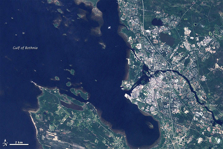
The city of Oulu, Finland, lies at the mouth of the Oulujoki River along the Gulf of Bothnia. The northerly location makes for cool summers and cold, dark winters. Today’s subarctic climate, however, is mild compared to that of its recent geologic history. As recently as 11,000 years ago, the area was buried under a glacier. The Landsat 7 satellite captured this image of Oulu on June 25, 2001. Urban areas are pale gray, bare ground is brown, vegetation is green, and water is navy blue. The Oulujoki River surrounds tiny islands en route to the sea in this low-lying area. Geologists surmise that during the most recent ice ages, the Fennoscandian Ice Sheet extended over a large expanse of northwestern Eurasia, reaching its greatest thickness about 20,000 years ago. The ice sprawled over Scandinavia and was thickest over the Gulf of Bothnia. The ice pushed primarily eastward across Finland, scouring away rock debris as it moved. As the climate warmed, the ice front gradually retreated. Roughly 11,000 years ago, the Oulu region was still buried by ice, but 1,000 years later, the ice had retreated westward, exposing western Finland and the Gulf of Bothnia. NASA Earth Observatory image created by Jesse Allen, using Landsat data provided by the United States Geological Survey. Caption by Michon Scott. The Earth Observatory's mission is to share with the public the images, stories, and discoveries about climate and the environment that emerge from NASA research, including its satellite missions, in-the-field research, and climate models. |
| Date | |
| Source | Oulu, Finland |
| Author | NASA's Earth Observatory |
| Camera location | | View this and other nearby images on: OpenStreetMap |
|---|
Licensing
- You are free:
- to share – to copy, distribute and transmit the work
- to remix – to adapt the work
- Under the following conditions:
- attribution – You must give appropriate credit, provide a link to the license, and indicate if changes were made. You may do so in any reasonable manner, but not in any way that suggests the licensor endorses you or your use.
| This image was originally posted to Flickr by NASA Earth Observatory at https://www.flickr.com/photos/68824346@N02/6411792223. It was reviewed on 2 July 2012 by FlickreviewR and was confirmed to be licensed under the terms of the cc-by-2.0. |
File history
Click on a date/time to view the file as it appeared at that time.
| Date/Time | Thumbnail | Dimensions | User | Comment | |
|---|---|---|---|---|---|
| current | 17:18, 2 July 2012 | | 720 × 480 (179 KB) | Dzlinker | == {{int:filedesc}} == {{Information |Description=To download the full resolution and other files go to: [http://earthobservatory.nasa.gov/IOTD/view.php?id=76512&src=flickr earthobservatory.nasa.gov/IOTD/view.php?id=76512&src=...] The city of Oulu, Fi... |
File usage
The following page uses this file: