
File:Macaulay of Lewis map.png

Size of this preview: 800 × 496 pixels. Other resolutions: 320 × 198 pixels | 640 × 397 pixels | 1,024 × 635 pixels | 1,290 × 800 pixels.
Original file (1,290 × 800 pixels, file size: 1.09 MB, MIME type: image/png)
| This is a file from the Wikimedia Commons. Information from its description page there is shown below. Commons is a freely licensed media file repository. You can help. |
Summary
| Description |
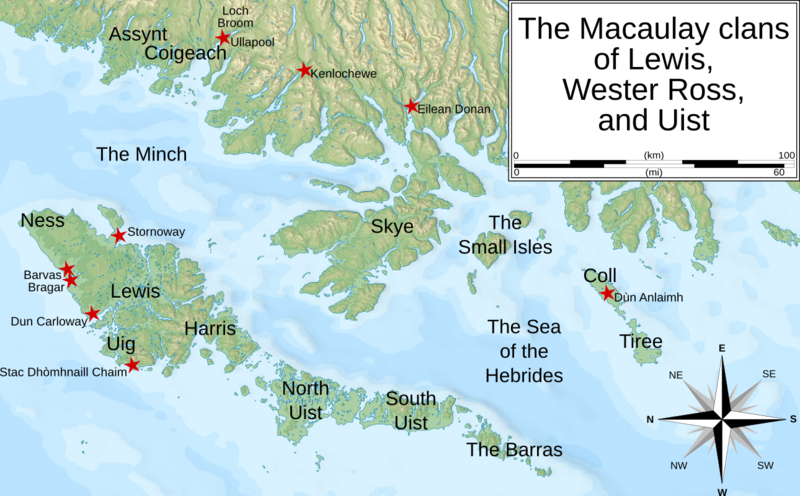
English: A map showing some of the key places dealing with the Macaulays clans from Lewis, Uist, and Wester Ross that are mentioned in the article: Macaulay of Lewis. |
| Date | |
| Source |
English: My own work using the following svg map. This vector image includes elements that have been taken or adapted from this file: |
| Author | Celtus (Celtus @ English-speaking Wikipedia) |
Licensing
This file is licensed under the Creative Commons Attribution-Share Alike 3.0 Unported license.
- You are free:
- to share – to copy, distribute and transmit the work
- to remix – to adapt the work
- Under the following conditions:
- attribution – You must give appropriate credit, provide a link to the license, and indicate if changes were made. You may do so in any reasonable manner, but not in any way that suggests the licensor endorses you or your use.
- share alike – If you remix, transform, or build upon the material, you must distribute your contributions under the same or compatible license as the original.
File history
Click on a date/time to view the file as it appeared at that time.
| Date/Time | Thumbnail | Dimensions | User | Comment | |
|---|---|---|---|---|---|
| current | 06:45, 18 November 2009 | | 1,290 × 800 (1.09 MB) | Brianann MacAmhlaidh | Adding Barvas and Dùn Anlaimh |
| 08:01, 30 June 2009 |  | 1,280 × 800 (1.07 MB) | Celtus~commonswiki | spelling: switched "Kenlochewe" to "Kinlochewe" | |
| 07:22, 30 June 2009 |  | 1,280 × 800 (1.07 MB) | Celtus~commonswiki | {{Information |Description=A map showing some of the key places dealing with the Macaulays clans from Lewis, Uist, and Wester Ross that are mentioned in the article: Macaulay of Lewis. |Sour |
File usage
The following page uses this file: