
File:BattleOfTheCedarsPhase2.svg

Size of this PNG preview of this SVG file: 768 × 600 pixels. Other resolutions: 307 × 240 pixels | 615 × 480 pixels | 984 × 768 pixels | 1,280 × 1,000 pixels | 2,560 × 1,999 pixels | 3,876 × 3,027 pixels.
Original file (SVG file, nominally 3,876 × 3,027 pixels, file size: 33 KB)
| This is a file from the Wikimedia Commons. Information from its description page there is shown below. Commons is a freely licensed media file repository. You can help. |
Summary
| Description |
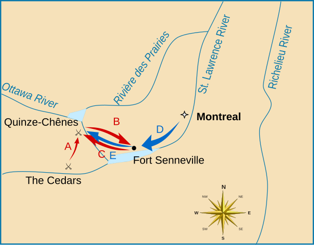
English: A map depicting military movements after the Battle of the Cedars in May 1776. Movements:
A, B: British advance to Fort Senneville, May 20-23 C: British retreat, May 24-25 D, E: American advance to Ottawa River crossing, May 26 |
| Date | |
| Source |
Own work using:
|
| Author | User:Magicpiano |
Licensing
I, the copyright holder of this work, hereby publish it under the following licenses:

|
Permission is granted to copy, distribute and/or modify this document under the terms of the GNU Free Documentation License, Version 1.2 or any later version published by the Free Software Foundation; with no Invariant Sections, no Front-Cover Texts, and no Back-Cover Texts. A copy of the license is included in the section entitled GNU Free Documentation License. |
This file is licensed under the Creative Commons Attribution-Share Alike 4.0 International, 3.0 Unported, 2.5 Generic, 2.0 Generic and 1.0 Generic license.
- You are free:
- to share – to copy, distribute and transmit the work
- to remix – to adapt the work
- Under the following conditions:
- attribution – You must give appropriate credit, provide a link to the license, and indicate if changes were made. You may do so in any reasonable manner, but not in any way that suggests the licensor endorses you or your use.
- share alike – If you remix, transform, or build upon the material, you must distribute your contributions under the same or compatible license as the original.
You may select the license of your choice.
File history
Click on a date/time to view the file as it appeared at that time.
| Date/Time | Thumbnail | Dimensions | User | Comment | |
|---|---|---|---|---|---|
| current | 20:12, 24 April 2010 | | 3,876 × 3,027 (33 KB) | Magicpiano | add small lakes near isle of montreal |
| 16:56, 20 April 2010 |  | 3,876 × 3,027 (32 KB) | Magicpiano | {{Information |Description={{en|A map depicting military movements after the w:Battle of the Cedars in May 1776. Movements: A, B: British advance to Fort Senneville, May 20-23 C: British retreat, May 24-25 D, E: American advance to Ottawa River cros |
File usage
The following pages on the English Wikipedia use this file (pages on other projects are not listed):
Global file usage
The following other wikis use this file:
- Usage on it.wikipedia.org
- Usage on ja.wikipedia.org