
File:Śląsk Cieszyński.PNG

Size of this preview: 461 × 599 pixels. Other resolutions: 184 × 240 pixels | 369 × 480 pixels | 591 × 768 pixels | 788 × 1,024 pixels | 2,000 × 2,600 pixels.
Original file (2,000 × 2,600 pixels, file size: 1.53 MB, MIME type: image/png)
| This is a file from the Wikimedia Commons. Information from its description page there is shown below. Commons is a freely licensed media file repository. You can help. |
| Description |
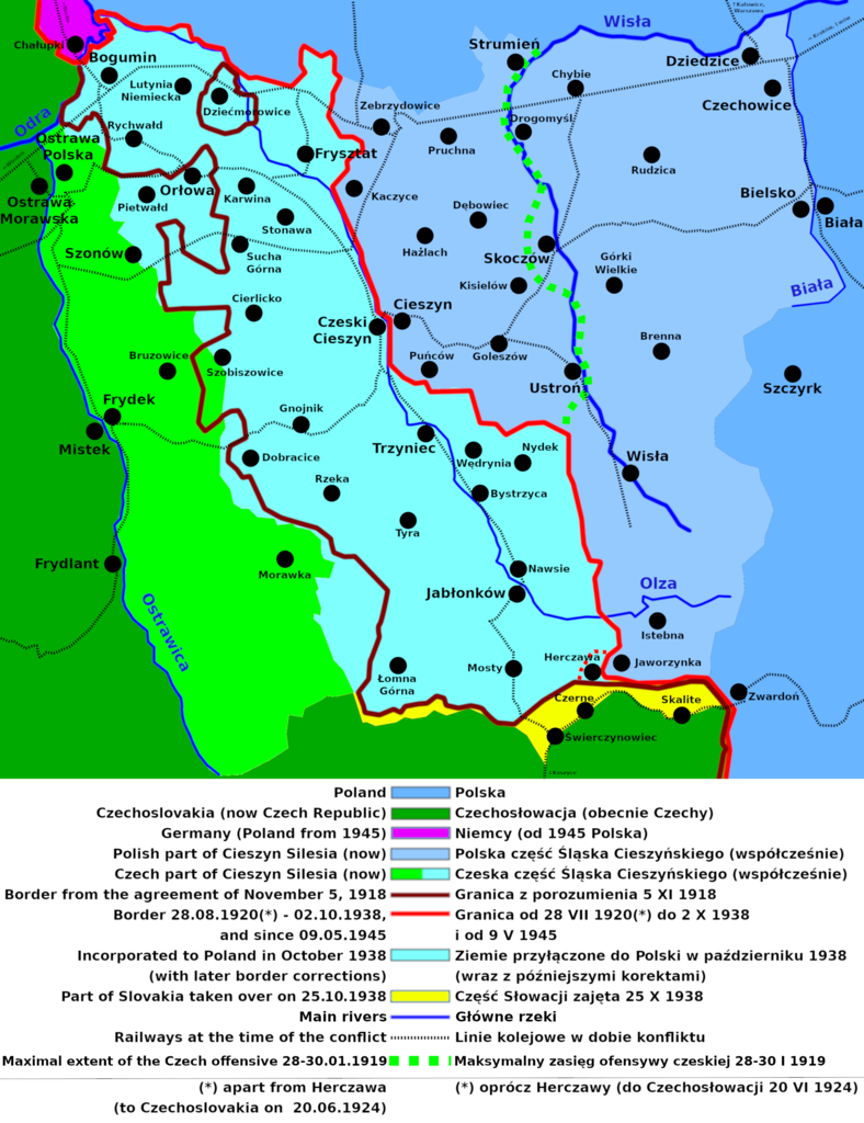
English: Map of Teschen Silesia and Polish-Czech border
Polski: Podział Śląska Cieszyńskiego
Deutsch: Karte von Teschener Schlesien mit polnisch-tschechischer Grenze |
||
| Date | |||
| Source | Own work | ||
| Author | Mix321 (redone by D T G | ||
| Permission (Reusing this file) |
I, the copyright holder of this work, hereby publish it under the following license:
|

File history
Click on a date/time to view the file as it appeared at that time.
| Date/Time | Thumbnail | Dimensions | User | Comment | |
|---|---|---|---|---|---|
| current | 10:37, 20 December 2018 | | 2,000 × 2,600 (1.53 MB) | D T G | added extent of the Czechoslovak offensive in the battle of Skoczów, small corrections |
| 08:43, 19 December 2018 |  | 2,000 × 2,540 (1.47 MB) | D T G | minor improvements | |
| 21:29, 18 December 2018 |  | 2,000 × 2,540 (1.47 MB) | D T G | further improvements and corrections | |
| 21:23, 17 December 2018 |  | 2,000 × 2,515 (1.43 MB) | D T G | reworked, corrections; more precise borders, railway lines | |
| 10:25, 29 October 2012 |  | 613 × 746 (47 KB) | Mix321 | legenda | |
| 11:55, 1 March 2010 |  | 613 × 740 (50 KB) | Mix321 | {{Information |Description={{en|1=Map of Cieszyn Silesia and Polish-Czech border}} {{pl|1=Podział Śląska Cieszyńskiego}} |Source={{own}} |Author=Mix321 |Date=2010.III.1 |Permission={{GFDL-self}} |other_versions= }} [[Category:Cieszyn |
File usage
The following 3 pages use this file:
Global file usage
The following other wikis use this file:
- Usage on ar.wikipedia.org
- Usage on be-tarask.wikipedia.org
- Usage on be.wikipedia.org
- Usage on cs.wikipedia.org
- Usage on de.wikipedia.org
- Usage on el.wikipedia.org
- Usage on eo.wikipedia.org
- Usage on es.wikipedia.org
- Usage on fr.wikipedia.org
- Usage on he.wikipedia.org
- Usage on hu.wikipedia.org
- Usage on id.wikipedia.org
- Usage on it.wikipedia.org
- Usage on ja.wikipedia.org
- Usage on pl.wikipedia.org
- Usage on ru.wikipedia.org
- Usage on sk.wikipedia.org
- Usage on uk.wikipedia.org
- Usage on zh.wikipedia.org